Rising above the confluence of the Middle Fork and Coast Fork Willamette Rivers, just minutes from downtown Springfield and Eugene, Oregon is 1,531-foot (467 m) Mount Pisgah. In this centerpiece of the 2,363-acre Howard Buford County Park, hikers can take to more than 20 miles (32 km) of excellent trails across this beautiful and ecologically diverse landscape.
The views alone of the Willamette Valley and the foothills of Oregon’s Central Cascades are enough of a draw to hike this peak named by early settlers for the mountain on which Moses first saw the promised land. But there’s more reasons to hike Pisgah’s verdant slopes. Come springtime the mountain’s oak savannah bursts into a kaleidoscope of flowers. This small mountain in Oregon’s heartland is one of the best places in Cascadia to see camas lily blooms.
There are several ways to get to Pisgah’s summit. And while the summit approaches are short (and often busy), plan on extending your hike with connecting trails leading to quiet meadows, wetlands, and forest groves. You can easily spend all day hiking within this park. Be sure to download the good map available from the Lane County Parks’ website. For the most direct approach to Pisgah’s summit, follow Trail no. 1, Beistel’s West Summit Trail.
Utilizing an old service road turned into a wide and smooth trail, this path climbs steeply at first before easing up upon reaching a broad ridge. Most of the way is fairly open granting excellent views northwest to Eugene and Springfield. There are good views too of the confluence of the Middle and Coast Forks of the Willamette River. Lying just outside of Oregon’s third- and ninth-most populated cities, this area mostly remains in a natural state. The Nature Conservancy owns a large tract on the confluence; and the preserved Dorris Ranch, a national historic site, also protects land along the rivers. These properties abut county parklands creating a greenbelt of more than 4,700 acres.
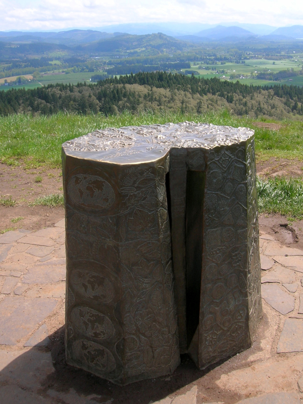
Take your time and soak up the views. Pick out Spencer Butte to the west. It’s a prominent landmark in Eugene and a popular hiking destination. And while the views are wonderful, Pisgah’s wildflower displays are supreme. Aside from camas, look for Oregon iris, Oregon sunshine (woolly sunflower), western buttercups, shooting stars, fawn lilies and plenty of other species. Once you reach the summit, admire too the bronze relief sculpture sitting upon it. The sculpture is a memorial to Jed Kesey, son of Springfield-raised Ken Kesey (counter-culture novelist best known for One flew over the Cuckoo’s Nest and Sometimes a Great Notion). Jed was a wrestler (like his dad) at the University of Oregon who died in 1984 at the age of 20 due to an accident involving the wrestling team’s van. Mount Pisgah overlooks the small community of Pleasant Hill, where Kesey lived.
After spending time on the summit consider taking a different trail for your return trip. They’ll all provide for a much longer return, bringing you to some of the park’s famous oak woodlands, prairies and savannahs.
Upon completing your hike or on a return visit, check out the park’s 209-acre Mount Pisgah Arboretum. A living tree museum, the arboretum has some beautiful family-friendly trails, including one along the Coast Fork of the Willamette River. And consider a trip in mid-May for the arboretum’s annual Wildflower and Music Festival.
Craig Romano is an award-winning author of more than 20 hiking books. Check out his detailed and trusted books and hit the trail!
Location: Howard Buford Recreation Area, Lane County, Oregon
Distance: 2.8 miles (4.5km)
Elevation gain: 1050 feet (320 m)
Difficulty: moderate
Trail notes: $4.00 parking fee; Dogs permitted on leash; bikes prohibited: some trails open to horses; practice Leave No Trace principles.
Trail highlights: spring and summer wildflowers, endangered plants, diverse ecosystems, exceptional views of Willamette Valley
Contact: Friends of Buford Park and Mount Pisgah
Getting to the trail: From Eugene, follow Franklin Blvd (Exit 189 I-5 southbound or Exit 188B northbound) to Seavey Loop Road (follow signs for park). Continue for about 1.5 miles (2.4 km) crossing river and turn righting onto Frank Parrish Road. Proceed 0.4 mile (0.6 km) to trailhead.

If you appreciate Craig Romano’s informative hiking articles, as well as all the other great writing and photography you find at Cascadia Magazine, please consider becoming a supporting reader and making a contribution at our donate page. We can’t do it without your help!
