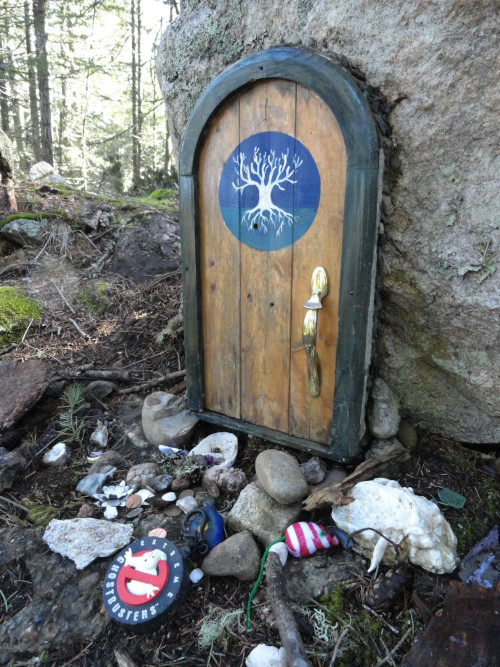
The highest peak on British Columbia’s Salt Spring Island (sans roads and towers), Erskine contains old-growth forest, impressive cliffs, and jaw-dropping views. The mountain is also home to endangered sharp-tailed snakes (a species at risk) and elusive forest fairies (read on). Until 2005, most of this 1,447-foot (441 m) peak was privately-owned. But thanks to the Salt Spring Island Conservancy, nearly 593 acres (240 hectares) on the mountain has been protected within two reserves and a provincial park.
Start your hike on the Jack Fisher Trail (aka “The Mount Erskine Assault Route”) and immediately begin climbing. Stay left at a junction and head up a rocky knoll sporting arbutus (madrona) and manzanita. The trail then makes a quick descent. Bear left again at a junction and resume climbing on a somewhat rocky route.
Shortly after entering the provincial park, reach a junction in a hollow of big firs, maples, and arbutus. This is a lollipop loop hike and you’ll be returning on the path straight ahead. So proceed right and steeply climb. Soon a trail (a not-recommended alternative summit route) veers right. Continue left, and shortly after come to the first of many intriguing and somewhat mystical fairy doors on rocks and tree trunks. Ask around at the Ganges Saturday Market for their story.
Reach a junction at a big fir. The way right loops .25 mile (.4 km) along steep, exposed ledges. The views are grand, but this is no trail for children and those skittish of drops. There are plenty of good views to be found going straight too; so keep hiking forward steeply, passing more elfin doors. Come to the steep side loop and after a few more steps emerge upon Erskine’s open summit dome.
Now closely holding any accompanying children and dogs, be wowed by the views–among the best in the Gulf Islands. Stare straight down at the tight strait, Sansum Narrows, and Maple Mountain above it. Watch ships and ferries sail to the mill town of Crofton. Scan Stuart Channel, eyeing the peaks of Vancouver Island to your left: Hall Mountain, Mount Prevost and Mount Arrowsmith among them. Then gaze at the islands to the right: Penelakut, Thetis ,and Valdes. Admire wind-contorted firs and pines and look for peregrine falcons. They’re fond of sharp-tailed snakes.
Notice too, the memorial bowl dedicated to Rosie the Wonder Dog.
Once you’re ready to continue hiking, follow a pleasant path east along the summit ridge, traversing mossy conglomerate ledges through attractive forest. Reach a junction with a trail heading to Manzanita Ridge. The first .4 mile (.6 km) of this trail provides excellent views north across Ganges to Wallace Island, Galiano Island and the Lower Mainland summits.
To continue your loop hike, head left and descend steep slopes of open forest until you reach a junction. The way right passes through big cedars reaching the alternative and easier approach Trustees Trail trailhead. To close your loop and return to your vehicle—turn left, soon coming to a familiar junction. Then veer right and retrace tread you’ve visited before back to your start.
Craig Romano is an award-winning author of more than 20 books. For detailed information on this hike and many others on Salt Spring Island and other Gulf Islands, pick up a copy of his Day Hiking the San Juans and Gulf Islands (Mountaineers Books).
Location: Mount Erskine Provincial Park, Salt Spring Island, British Columbia
Distance: 3.4 miles (5.5 km)
Elevation gain: 1,325 feet (404 m)
Difficulty: moderate
Trail notes: Dogs permitted on leash
Trail highlights: undeveloped Mountain on Salt Spring Island, exceptional and diverse habitat including old-growth, sweeping views
Contact: Mount Erskine Provincial Park
Gettting to the trail: From Vancouver (Tsawwassen) or Victoria (Swartz Bay) take BC Ferries to Salt Spring Island and proceed to Ganges. Then follow Rainbow Road west 2.7 miles (4.3 km) turning left onto Collins Road. Continue for .4 mile (.6 km) to trailhead located on your left; limited parking is on your right. If parking lot is full, consider accessing mountain from the Mount Erskine Upper Access Park Reserve, located in the Rainbow Grove Subdivision (off of Rainbow Road) at the end of Trustees Trail.

If you found this article informative, please consider becoming a supporting reader of Cascadia Magazine.
You can make a contribution at any level you’re comfortable with at our donate page.
And if you’re already a supporting reader, thank you!
